We arrived at our "campground" at Icefield Centre about 4:15 pm and signed up for the glacier tour for 6 pm. Our "campground was a bare parking lot with some lines painted on it. There were no services, but they did have a chemical toilet (which of course we didn't use) & it was $10.80 a night! This shows the Athabasca Glacier along with one of the original "snowmobiles" which the Brewster Company originally used to take passangers up and on the glacier.
 We took a bus from the center lodge to the area near the glacier where we boarded these Brewster's Glacier Explorers. These "snocoaches" cost about a million dollars to buy today. The driver was an excellent guide as well. We went immediately down a 35 percent grade on gravel and finally onto the glacier. I had to hide my eyes until we got closer to the bottom. Fortunately the driver was very good and went very slowly!
 When they drive through this part of the glacier road, where they deliberately dug it out, it washes the gravel off the tires in order to leave the glacier top surface cleaner. Otherwise the dirt accumulation could attract the sun, which would melt the glacier unnaturally.
 We are now getting near the top of the glacier where we will be able to get out.
 Part of the Andromeda Glacier, next to the Athabasca, which is called a hanging glacier since it "hangs off the rocks".
 This is a more distant view of the Andromeda Glacier, which has the hanging glacier as part of it.
 Jim and Lynda on the Athbasca Glacier with two icefalls & the head behind them. An icefall is when a glacier comes over a rock similar to a water fall. In this picture, we are standing about 1,000 feet off the ground; the glacier is that thick.
 More of smiling faces! It was a great experience to be out there on the glacier.
 We were not allowed beyond the cones because of the danger of the glacier having hidden crevasses. Two people have died on this glacier. This glacier is from the Columbia Icefield. It spawns several glaciers.
  Jim is standing by one of the tires of the snocoach, to give perspective.
 Lynda in front of the snocoach, which shows the vastness of this glacier. It is 3.75 miles long, 2.50 miles in area, 1000 ft deep at the deepest. We are at about 7000 ft above sea level here. The icefalls top is about 8,900 ft and the toes is about 6,300 ft.
  This looks like ski trails down part of the nearby mountain but actually are avalanche trails.
 This is looking back off the glacier at the mountain opposite this Athabasca Mountain.
.JPG) Here is the road back to where we leave the Snocoaches and get on the regular bus to return back to our RV. Look how small the Snocoaches are at the top! This is also the 35 degree hill- not as bad going up!
Here is the road back to where we leave the Snocoaches and get on the regular bus to return back to our RV. Look how small the Snocoaches are at the top! This is also the 35 degree hill- not as bad going up!
 This shows the Athabasca Glacier as it is melting and making streams, both on top and which sometimes go to the bottom to exit!
 Another view of the ice melting into a stream.
 This view also gives an idea of the vastness of the glacier, looking away from the icefalls.
 Thes are people walking along a trail to get a look at the foot of the glacier, as seen through my telephoto lens. Another way to show you the vastness of all this!
 Here you can see how small the snocoaches are in comparison to the glacier.
 Walking back to our RV from the bus, we came across this rabbit. It was my "treat from the Lord" that day! I think this is a snowshoe rabbit. What do you think? Look at the white feet.
 Here is the rabbit running away after posing for me. Look at those big white feet!
  This is a view of the glacier from our front window of the RV. It got really cold outside this night as the temperature dipped to 33 degrees!
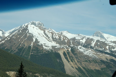 This is another mountain with a glacier which we saw as we drove north toward the town of Jasper. (In Jasper National Park)
 Another Jasper Mountain Scene with the Sunwapta River in foreground. This also is enroute to the town of Jasper on Rt 93. Gorgeous, eh?? (Canadian talk!) :-)
 This is Athabasca Falls. The Athabasca River cuts through very hard quartz-rich rock. It was a powerful falls!
 Maybe you can sense some of the power of the falls through this photo of the beginning!
 Another angle of the falls shows it's power as well as catching a rainbow- another "treat"! :-)
 This is the depth of the canyon which has been etched out by this river- the Athabasca.
 Jim is standing in one of the canyon areas no longer used by the river. It is a walkway down for other views of the canyon.
 Lynda is standing at the bottom of the stairs of that canyon no longer used by the river.
 After setting up at Whitler RV Park about 11:30, we drove around Jasper and the surrounding area that afternoon & evening. This is a lake nearby, called Lake Bouvert. I thought it was so beautiful! The water was so clear and blue-green.
 We took a side road to see Maligne Canyon, Medicine Lake and Lake Maligne. We had packed some sandwiches & drinks so time constraints were gone. We took our time. This is Jim at Maligne Canyon, which is a deep, narrow canyon cut by the Maligne River to a depth of 23 meters. (That's a math problem for you to convert to feet!)
 Here is the Maligne River falling into the canyon. It was pretty impressive! These rocks are limestone bedrock.
 Here is another view of another part of the canyon and other falls.
 Medicine Lake is the next item on this road. The Maligne River flows in but there is no apparent exit from the lake. The river flows from here underground to the Maligne Canyon where it resurfaces. There are pretty mountains in the background here also.
 While on the road, in a cliff area, we found what we think are mountain goats or stone sheep on the road.
.JPG) See how well these kids blend into the surroundings! These were very cute little guys.
See how well these kids blend into the surroundings! These were very cute little guys.
.JPG) Here is a mature goat on the right side of the road, above the lake. Notice that the goat is still shedding his winter coat.
Here is a mature goat on the right side of the road, above the lake. Notice that the goat is still shedding his winter coat.
This shows the Athabasca Glacier along with one of the original "snowmobiles" which the Brewster Company originally used to take passangers up and on the glacier. We took a bus from the center lodge to the area near the glacier where we boarded these Brewster's Glacier Explorers. These "snocoaches" cost about a million dollars to buy today. The driver was an excellent guide as well. We went immediately down a 35 percent grade on gravel and finally onto the glacier. I had to hide my eyes until we got closer to the bottom. Fortunately the driver was very good and went very slowly!
 When they drive through this part of the glacier road, where they deliberately dug it out, it washes the gravel off the tires in order to leave the glacier top surface cleaner. Otherwise the dirt accumulation could attract the sun, which would melt the glacier unnaturally.
 We are now getting near the top of the glacier where we will be able to get out.
 Part of the Andromeda Glacier, next to the Athabasca, which is called a hanging glacier since it "hangs off the rocks".
 This is a more distant view of the Andromeda Glacier, which has the hanging glacier as part of it.
 Jim and Lynda on the Athbasca Glacier with two icefalls & the head behind them. An icefall is when a glacier comes over a rock similar to a water fall. In this picture, we are standing about 1,000 feet off the ground; the glacier is that thick.
 More of smiling faces! It was a great experience to be out there on the glacier.
 We were not allowed beyond the cones because of the danger of the glacier having hidden crevasses. Two people have died on this glacier. This glacier is from the Columbia Icefield. It spawns several glaciers.
  Jim is standing by one of the tires of the snocoach, to give perspective.
 Lynda in front of the snocoach, which shows the vastness of this glacier. It is 3.75 miles long, 2.50 miles in area, 1000 ft deep at the deepest. We are at about 7000 ft above sea level here. The icefalls top is about 8,900 ft and the toes is about 6,300 ft.
 This looks like ski trails down part of the nearby mountain but actually are avalanche trails.
 This is looking back off the glacier at the mountain opposite this Athabasca Mountain.
.JPG) Here is the road back to where we leave the Snocoaches and get on the regular bus to return back to our RV. Look how small the Snocoaches are at the top! This is also the 35 degree hill- not as bad going up!
Here is the road back to where we leave the Snocoaches and get on the regular bus to return back to our RV. Look how small the Snocoaches are at the top! This is also the 35 degree hill- not as bad going up! This shows the Athabasca Glacier as it is melting and making streams, both on top and which sometimes go to the bottom to exit!
 Another view of the ice melting into a stream.
 This view also gives an idea of the vastness of the glacier, looking away from the icefalls.
 Thes are people walking along a trail to get a look at the foot of the glacier, as seen through my telephoto lens. Another way to show you the vastness of all this!
 Here you can see how small the snocoaches are in comparison to the glacier.
 Walking back to our RV from the bus, we came across this rabbit. It was my "treat from the Lord" that day! I think this is a snowshoe rabbit. What do you think? Look at the white feet.
 Here is the rabbit running away after posing for me. Look at those big white feet! This is a view of the glacier from our front window of the RV. It got really cold outside this night as the temperature dipped to 33 degrees!
Thursday, June 11, 2009 Our goal for this day was to get to the town of Jasper to camp for the night. There was much to see on the way!
 This is another mountain with a glacier which we saw as we drove north toward the town of Jasper. (In Jasper National Park)
 Another Jasper Mountain Scene with the Sunwapta River in foreground. This also is enroute to the town of Jasper on Rt 93. Gorgeous, eh?? (Canadian talk!) :-)This is Athabasca Falls. The Athabasca River cuts through very hard quartz-rich rock. It was a powerful falls!Maybe you can sense some of the power of the falls through this photo of the beginning!Another angle of the falls shows it's power as well as catching a rainbow- another "treat"! :-)This is the depth of the canyon which has been etched out by this river- the Athabasca.
 Jim is standing in one of the canyon areas no longer used by the river. It is a walkway down for other views of the canyon.
 Lynda is standing at the bottom of the stairs of that canyon no longer used by the river.
 After setting up at Whitler RV Park about 11:30, we drove around Jasper and the surrounding area that afternoon & evening. This is a lake nearby, called Lake Bouvert. I thought it was so beautiful! The water was so clear and blue-green.
 We took a side road to see Maligne Canyon, Medicine Lake and Lake Maligne. We had packed some sandwiches & drinks so time constraints were gone. We took our time. This is Jim at Maligne Canyon, which is a deep, narrow canyon cut by the Maligne River to a depth of 23 meters. (That's a math problem for you to convert to feet!)
 Here is the Maligne River falling into the canyon. It was pretty impressive! These rocks are limestone bedrock.
 Here is another view of another part of the canyon and other falls.
 Medicine Lake is the next item on this road. The Maligne River flows in but there is no apparent exit from the lake. The river flows from here underground to the Maligne Canyon where it resurfaces. There are pretty mountains in the background here also.
 While on the road, in a cliff area, we found what we think are mountain goats or stone sheep on the road.
.JPG) See how well these kids blend into the surroundings! These were very cute little guys.
See how well these kids blend into the surroundings! These were very cute little guys..JPG) Here is a mature goat on the right side of the road, above the lake. Notice that the goat is still shedding his winter coat.
Here is a mature goat on the right side of the road, above the lake. Notice that the goat is still shedding his winter coat.
No comments:
Post a Comment