We are still in Canada, changing routes from Rt 16, "The Yellowhead Highway", to Rt 97, the "West Access Route to the Alaska Highway". We now head south to Cache Creek on Rt 16 and then east to Kamloops on Rt 97.

It is nice to see large farms with hay and other crops. It is also nice to see electrical poles. We are in civilization! (Compared to rugged Canada & Alaska!)
.JPG)
As you can see, I love old barns! This one is near Hixon, BC.

The town of Quesnel had flowers growing everywhere! We loved it! This is their railroad station. Note that it is a two story RR station.

This is Williams Lake, near the town of Williams Lake.

This Bucking Bronco statue is famous for Williams Lake. People around here have lots of rodeos or "Stampedes", as they call them.
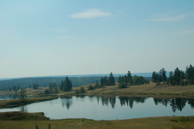
This is a high elevation pond, south of Williams Lake.

These barns are really old, just south of Williams Lake on Rt 97. (Don't you love them!)

This is a pretty lake called Lac La Hache.

This really old log barn is on Lac La Hache.

There are several towns on this road with the number and mile and house in the name. This is unusual, to me. Coming south out of the town of 100 mile house is a 7%, 3 mile hill. It was the first really warm day in weeks. We overheated going up the grade, turned around and went back to a truck repair place and had the mud pressure-washed out of our radiator. After that, the RV ran cool all the way up the long grade, no problem. Great combination - Freightliner chasis/Caterpillar engine/Allison transmission!
.JPG)
This is a brief, "fly-by view" of the town of Clinton, B.C.. It seemed quaint!

Scenic road south of Clinton.

Scenic church north of Cache Creek in an Indian town.

This was interesting. There are several of these dried up ponds, some all white, some with white in the middle and red on the outer ring. This one has lots of red on the outside edge. We need to find out what makes these colors. Any ideas?

In Cache Creek, Rt 97 does a 90 degree turn from south to east bound. (Check your map!) :-)

This is Savona Lake, west of Cache Creek.

Look how the terrain changes so much! It becomes very hilly and desert-like. Notice the scale by looking at the white dot, in the middle of the picture, that is an RV.

We made it to Kamloops, now to find the Walmart! This town is built on the sides of hills and there are no straight roads here. This made finding Walmart difficult, but we finally got there. By now the summer heat is catching up with us! The weather went from 56 degrees in Ketchikan last week to the high 80's here. And to boot, our dash air-conditioner doesn't work well.
.JPG) As you can see, I love old barns! This one is near Hixon, BC.
As you can see, I love old barns! This one is near Hixon, BC. The town of Quesnel had flowers growing everywhere! We loved it! This is their railroad station. Note that it is a two story RR station.
 This is Williams Lake, near the town of Williams Lake.
  This Bucking Bronco statue is famous for Williams Lake. People around here have lots of rodeos or "Stampedes", as they call them.
 This is a high elevation pond, south of Williams Lake.
 These barns are really old, just south of Williams Lake on Rt 97. (Don't you love them!)
 This is a pretty lake called Lac La Hache.
 This really old log barn is on Lac La Hache.
 There are several towns on this road with the number and mile and house in the name. This is unusual, to me. Coming south out of the town of 100 mile house is a 7%, 3 mile hill. It was the first really warm day in weeks. We overheated going up the grade, turned around and went back to a truck repair place and had the mud pressure-washed out of our radiator. After that, the RV ran cool all the way up the long grade, no problem. Great combination - Freightliner chasis/Caterpillar engine/Allison transmission!
.JPG) This is a brief, "fly-by view" of the town of Clinton, B.C.. It seemed quaint!
This is a brief, "fly-by view" of the town of Clinton, B.C.. It seemed quaint! Scenic road south of Clinton.
 Scenic church north of Cache Creek in an Indian town.
 This was interesting. There are several of these dried up ponds, some all white, some with white in the middle and red on the outer ring. This one has lots of red on the outside edge. We need to find out what makes these colors. Any ideas?
 In Cache Creek, Rt 97 does a 90 degree turn from south to east bound. (Check your map!) :-)
 This is Savona Lake, west of Cache Creek.
 Look how the terrain changes so much! It becomes very hilly and desert-like. Notice the scale by looking at the white dot, in the middle of the picture, that is an RV.
 We made it to Kamloops, now to find the Walmart! This town is built on the sides of hills and there are no straight roads here. This made finding Walmart difficult, but we finally got there. By now the summer heat is catching up with us! The weather went from 56 degrees in Ketchikan last week to the high 80's here. And to boot, our dash air-conditioner doesn't work well.
No comments:
Post a Comment